Sensoriamento Remoto UAV: "Elf" Grande Uso
Libere o tempo:
Aug 02,2024
Nos últimos anos, plataformas de veículos aéreos não tripulados transportando equipamentos fotográficos e outras cargas úteis de missão, controladas remotamente por pilotos ou controladas autonomamente por sistemas de controle de voo, desempenharam um papel cada vez mais importante em aplicações de sensoriamento remoto, como levantamento e mapeamento, redução de desastres e resposta a emergências. e tornaram-se novos membros da família do sensoriamento remoto. Os UAVs são conhecidos como os “elfos” da família do sensoriamento remoto devido à sua pequena manobrabilidade, voo de baixa altitude, alta resolução espacial e temporal e configurações de carga útil diversas e flexíveis. No entanto, este "elfo" é de grande utilidade!

In recent years, unmanned aerial vehicle platforms carrying photographic equipment and other mission payloads, remotely controlled by pilots or autonomously controlled by flight control systems, have played an increasingly important role in remote sensing applications such as surveying and mapping, disaster reduction and emergency response, and have become new members of the remote sensing family. UAVs are known as the "elves" of the remote sensing family because of their small maneuverability, low-altitude flight, high spatial and temporal resolution, and diverse and flexible payload configurations ". However, this "elf" is of great use!

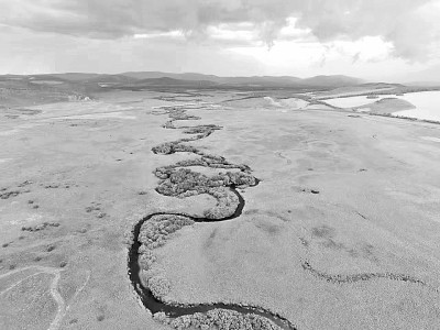
Photo for drone photography. Zhang Ginkgo/Bright Picture
100 years of research and development history, application in full swing
The commonly cited English name for unmanned aerial vehicles is Unmanned Aerial Vehicle(UAV). Generally, it refers to an aerial vehicle that is driven by power and does not carry operators. It uses aerodynamic power to provide the required lift for the aircraft. It can fly autonomously or remotely. It can be used once and can be recycled. It can carry lethal or non-lethal mission payloads, such as taking pictures, spreading drugs, playing sound, etc.
UAV is not a new thing, its development has been over a hundred years. In 1917, the Royal Aeronautical Research Institute initially combined aerodynamics, light engines and radio to develop the world's first unmanned aircraft. In December of the same year, American inventor Elmer Spee completed the first flight of the "aerial torpedo" using a gyroscope invented by himself and a radio control system developed by the Western Electric Company of the United States. In the beginning, UAVs were mainly used in the military field. After entering the 21st century, with the rapid development of modern electronics, precision machinery, navigation and positioning and remote sensors and other related technologies, the application of UAVs in the civilian field has become more and more extensive and formed an industry.

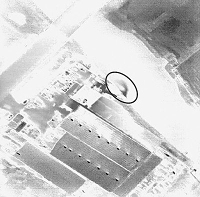
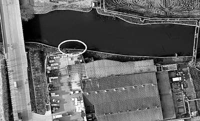
Images acquired by unmanned aerial vehicle monitoring of river sewage discharge. Photo by Yao Yanjuan/Guangming Picture
UAVs can be classified according to the use function, aerodynamic layout, power type, size and weight, flight speed, activity radius, flight height and other methods.
According to the use of functional division, drones can be divided into military drones, civilian drones and consumer drones. Military unmanned aerial vehicles can be divided into reconnaissance unmanned aerial vehicles, electronic countermeasure unmanned aerial vehicles, communication relay unmanned aerial vehicles, attack unmanned aerial vehicles and unmanned target aircraft. Civilian unmanned aerial vehicles can be divided into inspection, surveillance, mapping and detection unmanned aerial vehicles and agricultural unmanned aerial vehicles for various purposes. Consumer unmanned aerial vehicles are mainly used for personal aerial photography, games and other leisure purposes.
According to the aerodynamic layout, UAVs can be divided into fixed-wing UAVs, rotor-wing UAVs, flapping-wing UAVs and composite layouts. When flying, fixed-wing unmanned aerial vehicles rely on the power plant to generate forward thrust or pulling force. The main wing surface generating lift is fixed relative to the fuselage, mainly in the form of regular layout, canard layout, tailess or flying wing layout, triplane, etc. The rotor blades generating lift for rotor unmanned aerial vehicles rotate relative to the fuselage during flight, and can be divided into unmanned helicopters, multi-rotor unmanned aerial vehicles and unmanned rotary aircraft, the rotors of the first two types of unmanned aerial vehicles are directly driven by the power plant and can take off and land vertically and hover, while the rotors of unmanned rotary aircraft are driven without power. Flapping-wing unmanned aerial vehicles flapping up and down like bird wings to obtain lift and power, suitable for small and micro unmanned aerial vehicles; The compound layout unmanned aerial vehicles are composed of basic types, mainly including tilting rotor unmanned aerial vehicles and rotor/fixed wing unmanned aerial vehicles.
According to the type of power, UAVs are mainly divided into oil-powered UAVs and electric-powered UAVs. In recent years, UAVs with solar energy and hydrogen fuel cells as the core power have been continuously developed.
By size and weight, UAVs can be divided into micro UAVs, light and small UAVs, small UAVs, medium UAVs and large UAVs. The weight of the micro UAV is generally less than 1kg and the size is within 15cm. The weight of light and small drones is generally between 1 and 7kg, the weight of small drones is generally between 1 and 200kg, and the weight of medium drones is generally between 200 and 500kg.
Now, drones have become the "new favorite" of many children and big friends-consumer drones generally use low-cost multi-rotor platforms, mainly used for aerial photography, games and other leisure purposes. The domestic consumer drone market broke out around 2012. Prior to this, UAVs were mainly used in the industrial field, and the consumer market was mainly some model aviators and enthusiasts. At present, the development of my country's drone industry is showing a "blowout" trend. In addition to aviation and aerospace-related scientific research institutions and universities, many private enterprises have joined the ranks of research and development. The research and development and application of civilian drones are in full swing. The application of consumer entertainment and other fields has been in the forefront of the world.
2 new remote sensing platform, showing unique advantages
The rapidly developing UAV has become a new remote sensing platform. After carrying various remote sensors, it is widely used in land aerial survey, agriculture, forestry and plant protection, atmospheric exploration, disaster rescue, national defense security and other fields.
UAV remote sensing has the ability of ultra-high resolution and high frequency acquisition, which can complement satellite remote sensing. Compared with human-machine remote sensing, it has high cost performance and mobility. The real-time observation capability of UAV remote sensing is difficult to achieve by satellite remote sensing observation platform at present.

Images acquired by unmanned aerial vehicle monitoring of river sewage discharge. Photo by Yao Yanjuan/Guangming Picture
Satellite remote sensing can provide images at the sub-meter level, but the higher the resolution, the greater the satellite revisit period. UAV images can easily provide centimeter or even higher resolution ground information, and there is no contradiction between high spatial resolution and time resolution, and the dialectical unity of space and time is realized on the basis of low cost. It can be said that the emergence and rapid development of UAV remote sensing has made a big step forward in remote sensing scientific research from macro to micro. Compared with the high cost and centralized management of satellite platforms, UAV platforms enable remote sensing data acquisition to enter the era of popularization and truly realize the remote sensing application of to C (users).
Due to the unique advantages of UAV remote sensing, many fields that were not effective or could not be realized based on satellite data in the past can be well implemented by UAV remote sensing. For example, the use of UAV hyperspectral remote sensing can be used to classify and identify surface species, discover and identify alien species invasion through UAV hyperspectral data, and provide data support for ecological environment protection. For another example, UAV remote sensing provides convenient conditions for extreme environmental sampling and data acquisition, provides first-hand data for many studies, and helps many new scientific discoveries. Since 2010, NASA has assisted in the construction of a typhoon fine structure system after successfully monitoring the path of five hurricanes in the Atlantic Ocean using the high-altitude long-endurance UAV "Global Hawk" (GlobalHawk). In 2017, multinational research teams used drones equipped with cameras and other sensors to take pictures of the eruption of Guatemala's volcano on the island of Fuego, measure relevant data, and model the dynamic process.
In particular, it is worth mentioning that UAV remote sensing plays a key role in disaster remote sensing monitoring. In the major natural disaster emergency events in recent years, drones can be seen: in the rescue after the Wenchuan earthquake in 2008, drone remote sensing technology was put into use; subsequent major natural disasters, such as landslides in Maoxian, Sichuan, UAVs have played an important role in emergency relief such as the oil spill in Dalian and the explosion of dangerous chemicals in Tianjin Port.
In the field of industrial application, the inspection of oil and gas, transmission and photovoltaic electric field infrastructure has been normalized. In some government departments, UAVs are gradually being incorporated into the business system, such as the environmental protection department using UAVs to carry out investigation and remediation of river sewage outlets. The high-frequency, fast-response UAV platform and centimeter-level UAV images strongly support the daily operation of regular operations of environmental protection-related business departments.
3 "remote sensing +" applications, expanding service areas
Due to the convenience and flexibility, high public participation, UAV innovation activity is also very high, rapid development. The in-depth combination of UAV remote sensing and other related technical fields presents a large number of expansive applications, which are called "remote sensing +" applications of UAV. For example, in the real-time transmission of "remote sensing + data", UAV remote sensing is very important for military, emergency disaster reduction and rescue, and many homeland security monitoring and disaster rescue operations rely on UAV remote sensing and real-time transmission to provide timely information for decision-making.
In the aspect of "remote sensing + real-time positioning and mapping technology (SLAM)", the combination of UAV and SLAM enhances the navigation and obstacle avoidance of UAV, which has an important application prospect in the intelligent data acquisition and autonomous flight of UAV.
In terms of "remote sensing + decision-making and execution technology", the integration of "UAV remote sensing + identification + mission planning + mission execution" is realized. For example, UAV remote sensing can realize remote sensing monitoring of field agricultural conditions, form pest and disease prescription maps, plan reasonable routes, carry out accurate pesticide spraying, and integrate static remote sensing observation with real-time decision-making and execution.
In terms of "remote sensing + low-altitude route planning", the current diversified application requirements of unmanned aerial vehicles are mainly at low altitude. Most of the "low, slow and small" unmanned aerial vehicles are concentrated in the near-ground airspace below 500 meters. However, the surface changes of this airspace are diverse, the situation is complex, and the problems of flight safety and efficiency are prominent. Therefore, the low-altitude route, especially the low-altitude public route of unmanned aerial vehicles in urbanized areas, need fine planning. Obtaining data through traditional statistical channels is inefficient, and the use of high-definition high-dynamic UAV remote sensing data in urban areas to serve low-altitude route planning has become the forefront of research, China has taken the lead in this regard to carry out active exploration.
In terms of "remote sensing + regional networking", although the UAV has strong remote sensing capability and high spatial resolution, the coverage area is small and it is difficult to meet the needs of large-area applications for UAV remote sensing. For example, through a certain organizational model and technical system, the national distributed UAV remote sensing resource planning and deployment, to build a large area, high frequency, fast response of the centimeter resolution and remote sensing monitoring system, so as to complete the large area of measurement tasks.
In general, the application and development of UAVs have formed a trend of application in all fields. With the strong traction of application requirements and the strong support of new technology development, the development of UAVs can be expected in the future.
Guangming Daily (16th Edition, January 25, 2024)
Palavras chaves:
Notícias Relacionadas
Drones: do consumidor ao profissional
Sensoriamento Remoto UAV: "Elf" Grande Uso
Foco em drones de consumo no campo de batalha
Shenzhen UAV Indústria Entra Flower Age, Mais de 1730 Empresas Output Value 96 bilhões Yuan
Notícias conselhos
Navegação coluna
Contate-nos
Endereço: Rongxin Center, Haicang District, Xiamen, Fujian Province
Telefone: 86 18350212718
Carro: 86 18350212718
Correio eletrônico:Athena@enjoyoriginal.com
Sítio Web:www.ptjoyoriginal.com
Direitos autorais©2024 Fujian ORIGINAL Importação e Exportação Co., Ltd. |Licença comercial|Tags SEO|Subestação Cidade| Desenvolvido por:www.300.cn


